Beavertail State Park History (1980)

The State of Rhode Island Department of Environmental Management, Division of Parks and Recreation has worked with the Town of Jamestown toward the creation of Beavertail State Park, which is comprised of Federal Surplus Land. In moving toward this goal, the Department and the Town have analyzed the characteristics of the land in question and have developed a park which will meet the needs of the users while preserving the fragile ecological, scenic and historical attributes of Beavertail. Over the past few years, this area has seen a major increase in attendance with park visitors. It appears that Beavertail has a lot to offer the public with both its low-key development and pristine environment. Beavertail's most popular activity has been sightseeing, whether done from the comfort of a vehicle, or from one of the four scenic overlooks or from the rocky coastline. Also, Beavertail boasts some of the best saltwater fishing around, hiking trails, and a Naturalist Program which attracts hundreds of people each year.
BEAVERTAIL LIGHTHOUSE HISTORY
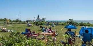
The first Beavertail Lighthouse was built in 1749 and was the premier lighthouse in Rhode Island, third in the country following the 1716 Boston Harbor light and the 1746 Great Point light on Nantucket. Although this wooden tower was burned to the ground in 1779 by British Soldiers, the foundation of the first lighthouse remains on the site. The present granite lighthouse was constructed in 1856 and remains an iconic landmark for Rhode Islanders and visitors to the Ocean State. The base of the older tower was exposed by the Hurricane of 1938, and today is marked by a granite plaque erected by the Jamestown Historical Society. Known for many years as the Newport Light, the Beavertail beacon was first to witness the triangular trade which contributed to Newport's prominence before the Revolution, when ships carried molasses, rum, and slaves between the colonies, the West Indies and Africa. The British damaged the building in their retreat from Rhode Island in 1779, but a few years later, the light was reactivated to guide vessels of Rhode Island merchants engaged in the trade with China. The Lighthouse and Lighthouse Museum are now operated by the Beavertail Lighthouse Museum Association. For more information on the Association see their website at: www.beavertaillight.org or write them at: Beavertail Lighthouse Museum Association, PO Box 83, Jamestown, RI 02835. Also, you can contact the Jamestown Town Hall at (401) 423-7220.
WORLD WAR II HISTORY:
Beavertail's strategic location as a forward peninsula, straddling two of the coastal passages from the Atlantic Ocean to Narragansett Bay, made it a key sentinel guarding one of America's 'Arsenals of Democracy' in the Second World War. Behind the picket line of coastal forts and observation posts stretching from Point Judith to Little Compton was a bee hive of wartime manufacturing and a major marshaling yard for supporting the war in Europe. There was the Walsh Kaiser shipyard in Providence turning out Liberty-type cargo ships, the Herreshoff boat yard in Bristol making PT boats, the Newport-based Destroyer Fleet, the Naval War College and Naval Training Station, the Torpedo factory on Goat Island, Quonset/Davisville with its Seabee Battalion, the facility for building Quonset Huts, the Naval Air Station, and so forth.
At the center of this picket line protecting all this wartime activity was Fort Burnside on Beavertail featuring the Harbor Entrance Command Post which monitored all the comings and goings of military shipping while minding the horizon against possible enemy attack. A thicket of radio antennae, backed up by the latest radar, the command post posed as an innocent farm house. Within it was a hardened military observation post on top of a war-room bunker that served as the eyes and ears of a network of 3 inch and 6 inch artillery batteries from Forts Greene and Varnum on Point Judith (now Fishermen's Memorial State Park), to Forts Kearney, Greble, and Getty, (near the mid-section of Jamestown), Fort Wetherill (now also a state park), to the Fort Adams and Brenton Point in Newport (also state parks), to Fort Church in Little Compton. Enormous 16 inch coastal guns which could fire out to sea some 26 miles in intersecting arcs depended on the surveillance of the equipment housed at Fort Burnside and on a series of fire control posts that had been established along the southern shores of Rhode Island. Anti-submarine nets stretched across the passage openings and loops of listening devices further out to sea completed the warning system. The network served from 1942 until the surrender of the Nazis in 1945.
FORT BURNSIDE HISTORY:

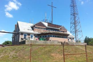
Outwardly built to mimic the look of a country farmhouse, Fort Burnside's main structure or "HECP" (harbor entrance control post) was constructed to protect military personnel and equipment from sea-borne attacks. The main bunker within the structure is comprised of 36-inch hardened, reinforced walls. A wooden shell disguises the concrete so, at a distance at sea, the building resembles a cottage rather than a military structure.
During World War II, approaching vessels were observed at Fort Burnside using both visual and electronic means of detection. In addition to human lookouts, there were underwater microphones in several large groups positioned strategically south of Beavertail with a terminal at the HECP. There were also several "magnetic loops" - coils of wire specifically placed to detect the passage of a large ferrous (steel) body of a ship or more importantly, a submarine.
During the war, two anti-submarine nets were spanned across the bay. The first net was used to block all navigation of the west passage and spanned from Fort Kearny (now the URI school of oceanography) to Fort Greble (Dutch Island) and then to Fort Getty on the west side of Jamestown's Connanicut Island. The second net spanned from Fort Wetherill on Jamestown to Fort Adams in Newport. This net had the ability to open and close by net-tending boats. Control of the net was exercised on command from the HECP after they had determined a vessel was cleared for entry into Newport Harbor.
Radar was in its infancy during the early 1940's and Fort Burnside had two of the early coastal radars in use. At the beginning of the war, they were used together with telescopes to aim the fort's coastal defense weapons which consisted of large-caliber guns on either side of Narragansett Bay. At the end of the war, the coast artillery was essentially obsolete and the guns were scrapped.
Fort Burnside went on to perform a number of functions including modern harbor defense and as a communication center during the beginnings of the Cold War. The fort's direct military service ended in 1978 when the Naval reserve group who had occupied the fort was disbanded. Recently, however, the fort has come full-circle with the installation of a radar and surveillance cameras mounted on the 110-foot tower built in 1951 on the east side of the building by Homeland Security.
