
Fort Adams State Park (1965)
Before being deeded to the State of Rhode Island in 1965, Fort Adams had served the U.S. Navy for ten years and the U.S. Army for more than a century. Since its acquisition by the state it has made national history in the entertainment field of Jazz and Folk festivals and as a base for Newport sailing. More recently it has come into its own as a repository and expository of military history. By arrangement with the state, the Fort Adams Foundation has been at work restoring the fort for decades, but only recently has the sheer magnitude of the importance of this landmark in its field of fortification truly been revealed. Since its inception in 1994, the Trust has spent nearly ten million dollars on restoration and now features permanent exhibits, historic tours of the site and frequent special events of military history. There’s more to be done, but the basic story of the Fort can now be seen and understood.
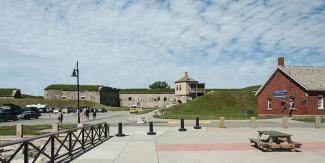
The Fort rests at an elbow to the entrance of Newport Harbor. Ships need to enter the East Passage of Narragansett Bay, passing the Coast Guard station and lighthouse at Castle Hill and the Hammersmith Farm of the Kennedy family, before coming broadside to Fort Adams on the east and Fort Wetherill on Jamestown to the west. This ‘choke point,’ commanded before Fort Adams by a colonial battery on one side of the passage and Fort Dumpling on the other, was a good location to foil sea invaders to Newport Harbor, which lies beyond these sentinels. Further up the passage was another fort on Goat Island. In colonial times this emplacement which formed a kind of triangle with the former was known successively as Fort Anne, Fort George, and Fort Liberty.
Protecting Newport from attack and invasion was always on the minds of Rhode Islanders. Located on Aquidneck Island, sometimes known as Rhode Island, from 1690s until the outbreak of the American Revolution, Newport presided over the golden age of shipping commerce and the making of fortunes for merchant princes who mastered a food-supply trade with the West Indies, dabbled in privateering in England’s wars with France and Spain, and became the work horses of the nefarious American slave trade – shipping rum to Africa, slaves to the Caribbean, and molasses back to Rhode Island where it was distilled into rum. Sheltering the continuity of this activity from invasion and attack were the colonial forts at the entrance to the harbor.
The colonial legacy assumed by Fort Adams began with Brinton himself who reportedly ordered two cannons to protect his property from pirates and privateers. In 1740, an observation post was erected on the site. Earthwork fortifications appeared during the French and Indian War.
Fort Adams, which was built after the Revolution, didn’t play a role in the golden age of Newport’s merchants. Its place was to protect the growth of the American Navy which chose Newport and Narragansett Bay in the early 19th century as one of the best harbors along the Atlantic coast for its needs. Officially, Fort Adams sits astride Brenton Point. This sometimes leads to confusion because a couple of miles away, closer to the ocean is Brenton Point State Park. Initially, all the land between Fort Adams and Brenton Point was owned by William Brenton, one of the early founders of Newport. Fortification of the site at the outbreak of the Revolutionary War occurred in the spring of 1776, but it was captured very quickly when a large British fleet and an invasion force occupied the town in December of the same year. For three years, Newport lay behind enemy lines until the British garrison was withdrawn in October of 1779, and the initial installation at Brenton Point was destroyed. Twenty years transpired (1799) until the site was re-occupied by a battery of cannon, named after John Adams, second President of the United States who authorized its construction.
It wasn’t, however, until a quarter of a century more transpired, that in 1824 construction began on the true Fort Adams which was to become ‘the largest coastal defense works of its kind in the United States.’ The justification for building such an extensive fortification was that in the eyes of the Navy board responsible for the system of coastal defenses in the early 19th century, “only Narragansett Bay among northeastern harbors could shelter ships during violent storms, and between Cape Cod and Cape Hatteras only Narragansett Bay and Hampton Roads (Virginia) were regarded as ‘proper for naval rendezvous’.” The thirty-three years of construction to follow were largely the work of Irish laborers, who built their own community nearby in the Fifth Ward of Newport and also built the Catholic church within which Senator John F. Kennedy and Jacqueline Bouvier were later married.
The cost of building Fort Adams for three decades was over three million dollars. It was designed to mount 468 guns around a perimeter of over 1700 yards. It used a combination of Maine granite, brick, and shale. During a time of war it could house 2400 men, though a peace time garrison of 200 was sufficient. The result was the design and work of two prominent engineers, Simon Bernard, a former aide to Napoleon and Joseph G. Totten, who later became the first head of the Army Corps of Engineers. Their problem was to defend the location by both sea and land attack and they relied on the classic military science developed by Sebastien Le Prestre de Vauban, the engineer for King Louis XIV of France. Depth and redundancy of defense was the key ingredient.
A series of defensive lines was built on the site. Structures known as tenailles, bastions, and redoubts, which were angled in such a way as to create deadly crossfires, were employed to stop any attack by land. On the seafront, the bomb-proofed casemates were designed to house two cannons rather than the single weapon typically employed. As the century progressed, however, and the design of artillery improved and became more powerful, strengthening the fort became necessary from time to time.
In the 1880s, during the period of the so-called Endicott system of new and revised fortifications, improvements to Fort Adams took place outside of the fort by installing new batteries along the East Passage, south of the Fort. In 1906 to 1908 interior remodeling occurred. The Fort was an active post during the Civil War, the Indian Wars, the Mexican War, the Spanish American War, and the two World Wars. It was in World War II that it played perhaps its most active role. Nearly the entire State of Rhode Island became a military district with its considerable manufacturing capability turning out everything from Liberty ships, torpedo boats, torpedoes, Johnson carbines, the Oerlikon 20 mm anti-aircraft cannon, Quonset Huts, rubber life rafts, and uniform jewelry pins of all kinds. The southern part of the state, however, had coastal defenses strung like chains of the jewelry industry from Point Judith to Fort Church at Little Compton. The nerve center of this defensive picket line was Fort Adams. It was home to the 243rd Coast Artillery after September, 1940. From there and the Harbor Entrance Control Post at Fort Burnside at Beavertail the defense of the Rhode Island military district was directed.
Army use of the Fort continued after World War II until 1953. This is when the Navy took charge of the site. Land south of the Fort was used for Naval housing, Newport at the time hosting a large contingent of personnel for various fleet activities. It was during this time that President Dwight D. Eisenhower used the Commanding Officer’s residence, a large home dating from the Victorian period, as a summer White House. As the Navy began a reduction of force in the area, the State of Rhode Island acquired the main fortification and outer works in 1965.